

A brief history of South Karelia
The Finnish Karelia of today consists of the separate and distinct regions of South and North Karelia. Karelia was divided in this way as early as the Middle Ages when the first boundary between Swedish domains, on the one hand, and the principality of Novgorod on the other was laid down in the Treaty of Pähkinäsaari (1323) – the date when the documented history of Finland begins. The areas making up present-day South Karelia were divided in such a way that lands to the south of Vuoksi and Simpele remained under Swedish influence whereas the lands to the north were ruled by Novgorod. Consequently Vyborg became the centre of Sweden-Finland’s Karelia whereas Käkisalmi (Kexholm) became the major town in the Novgorod-dominated Karelia.
The frontier drawn up under the Treaty of Pähkinäsaari remained in force for well over two hundred and fifty years, with no changes taking place along the eastern border until 1595 in which year the Treaty of Täysinä was signed. For South Karelia itself the changes of territory were only minor in scope, although Sweden as a whole managed to considerably expand its territory to the north. Also under this treaty the parish of Jääski was joined to the kingdom of Sweden-Finland.
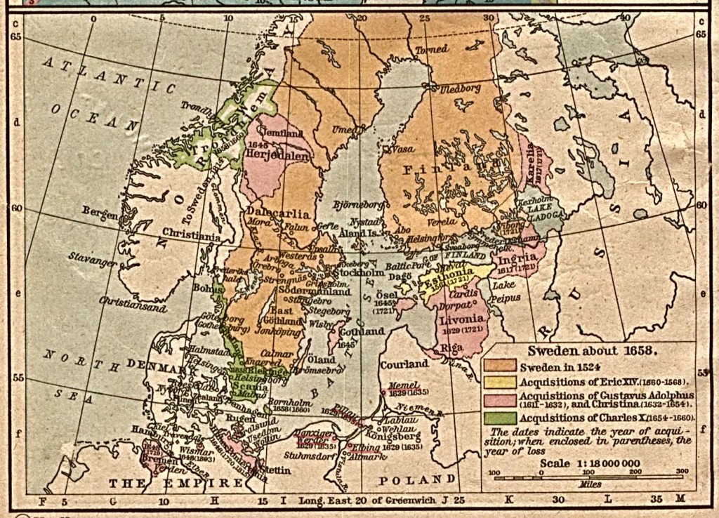
Sweden (including Finland) about 1658
The peace agreed under the Treaty of Täysinä was short-lived. War between Sweden and Russia broke out once more in 1609, peace was again negotiated in 1617 with the Treaty of Stolbova under the terms of which Sweden expanded its territory to the east and gained control of the areas of Karelia around Käkisalmi as well as Ingria (today the area around St Petersburg). At this time the Swedes also decided to impose Lutheranism on the population of their new territories. Thus, when the so-called War of Rupture broke out from 1656 –1661, it bore all the hallmarks of a religious war with the Russians attacking in order to liberate those of the Orthodox faith from Swedish rule.
Karelia was once again divided in 1721 when, after defeat in the Great Northern War of 1700-21, Russia was forced to relinquish most of Finland under the terms of the Treaty of Uusikaupunki (Nystad). Some two decades later, during the so-called Lesser Wrath (1741-43), Sweden attempted to retake the territory it had previously lost to Russia but in the decisive battle of Lappeenranta (August 1741) the Russians took the Fortress. By the Treaty of Turku, signed in 1743, the Russian border was advanced still further west in southern areas of Finland: the present-day South Karelia and Kymenlaakso up to the River Kymi, along with the Savonlinna district, were ceded to Russia at this time. In practice this meant that Russia gained control of all border fortresses, including the Fortress of Lappeenranta, and thus the whole region was effectively a protection zone and buffer for the newly-constructed capital of Russia, St. Petersburg.
Contemporaneous with the Napoleonic Wars, however, a further Finnish War between Russia and Sweden broke out in 1808. At the conclusion of this with the Treaty of Hamina in 1809, Finland was completely annexed to Russia and was declared an autonomous Grand Duchy. In addition, Tsar Alexander I returned to the Grand Duchy of Finland those territories (including South Karelia) which had been annexed by means of various treaties in the preceding century. These territories were now reconstituted as the Vyborg Province of the Grand Duchy of Finland.
Finland gained her full independence from Russia in 1917. At this point the Russo-Finnish border remained geographically as it had been during the period of the Finnish Grand Duchy, and this meant that the two Karelias were now re-united. However, this situation was soon to change once more with the Winter War of 1939-40. This was concluded with the signing of the Peace of Moscow in 1940 under the terms of which, once again, Karelia was bisected, with the eastern frontier redrawn virtually to the point where the border can be found today. What we now know as South Karelia remained on the Finnish side of the border. During the Second Finnish War, known to Finns as the Continuation War, Finland first gained control of the territories ceded in 1940, but the terms of the armistice signed in Moscow in 1944 (and ratified by the Treaty of Paris in 1947) re-established the borders between Russia and Finland which remain in today’s Karelia. As a consequence, South Karelia became once more a borderland between Finland and what was then the Soviet Union and is now, once again, Russia.
The region of South Karelia continues the traditions of the old Vyborg Province and the Karelian Isthmus. In 2012 the region consists of 8 municipalities and two towns. Of these, Lappeenranta, founded in 1649 around the ancient trading place at Lapvesi, is the largest in the region and also the administrative centre. The region’s other major town is Imatra. Imatra was constituted as a town in 1971 having been originally founded in 1948 as a borough made up of those areas of Ruokolahti, Joutseno and Jääski lying on the Finnish side of the border. Over the centuries, the municipalities of the region have mainly been created from the large mother parishes of Taipale (Taipalsaari), Jääski and Ruokolahti.
There have been a number of changes in the municipal field during the 2000s. Consolidation of municipalities in South-East Karelia has reduced the number of municipalities, and more changes are expected in the next few years. The municipalities of Saari and Uukunniemi were annexed to Parikkala at the beginning of 2005. Joutseno was annexed to Lappeenranta in 2009, and the municipality of Ylämaa the following year. At the beginning of 2013, the municipality of Suomenniemi will be annexed to the city of Mikkeli, thus also transferring it to another province.
 Copyright secured by Digiprove © 2013 Alternative Finland
